Colle del Lys
Medium
Landevejscykel
Naviger
Naviger
Få denne tur på din mobiltelefon
Kort
Colle del Lys
Medium
Landevejscykel
75.92 km
Scan QR-koden, og start navigationen i bergfex -appen
QR Code
Vandring og sporing
Vandring og sporing

Colle del Lys

Medium
Landevejscykel
Afstand
75.92 km
Varighed
04:30 h
Opstigning
1192 hm
Havets niveau
328 - 1307 m

Sværhedsgrad: 3

Download af spor
Kort
Colle del Lys
Medium
Landevejscykel
75.92 km

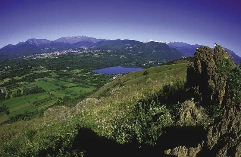
The route connects the Lower Susa Valley and the Lanzo Valleys. From the hill, you can admire a suggestive panorama that extends from the plains north of Turin to the Cuneo area, all the way to the Maritime Alps.


Rute
Cappella della Madonna di Vicoforte
(791 m)
Sted for tilbedelse
9.1 km
Borgata Bertassi
(907 m)
Afregning
11.7 km
Ciatera
(796 m)
Afregning
28.8 km
Cappella dell′Addolorata e di San Michele Arcangelo
(724 m)
Sted for tilbedelse
34.8 km
Colbeltramo
(670 m)
Afregning
40.0 km
Santa Maria della Spina
(354 m)
Sted for tilbedelse
65.4 km
San Giorgio Martire
(371 m)
Sted for tilbedelse
69.5 km
Rute
Kort
Colle del Lys
Medium
Landevejscykel
75.92 km
Grangia
(339 m)
Landsby
0.0 km
Almese
(368 m)
Landsby
2.3 km
Villar Dora
(352 m)
Landsby
2.6 km
Rubiana
(614 m)
Landsby
6.8 km
Sant'Egidio Abate
(643 m)
Sted for tilbedelse
7.0 km
Cappella della Madonna di Vicoforte
(791 m)
Sted for tilbedelse
9.1 km
Mollarbrunatto
(790 m)
Afregning
9.4 km
Grandi
(850 m)
Afregning
10.6 km
Ferro-Raimondo
(800 m)
Afregning
10.7 km
Borgata Bertassi
(907 m)
Afregning
11.7 km
Mompellato
(1088 m)
Afregning
14.0 km
Colle del Lis
(1311 m)
Korridor/terræn
16.0 km
Niquidetto
(1185 m)
Afregning
19.8 km
Ristorante Bar La Baita
(1145 m)
Restaurant
22.4 km
Colletto
(1152 m)
Afregning
22.5 km
Col San Giovanni
(1118 m)
Afregning
23.9 km
La Comba
(1113 m)
Restaurant
24.1 km
Chiapestron
(933 m)
Korridor/terræn
26.7 km
Ciatera
(796 m)
Afregning
28.8 km
Molar Michele
(788 m)
Afregning
28.9 km
Fucine
(720 m)
Afregning
29.9 km
Versino
(761 m)
Afregning
31.0 km
Viù
(785 m)
Landsby
31.7 km
La Nuova Cà Bassa
(769 m)
Restaurant
31.8 km
Ristorante Moderno
(764 m)
Restaurant
31.8 km
Molartissier
(806 m)
Afregning
31.9 km
Oldri
(778 m)
Afregning
32.5 km
Mondrezza
(730 m)
Afregning
32.7 km
Chiesa di San Giovanni Battista
(738 m)
Sted for tilbedelse
34.0 km
Lou Sulè
(724 m)
Restaurant
34.8 km
Cappella dell′Addolorata e di San Michele Arcangelo
(724 m)
Sted for tilbedelse
34.8 km
Fubina
(720 m)
Afregning
34.9 km
Borgo
(601 m)
Afregning
38.2 km
Colbeltramo
(670 m)
Afregning
40.0 km
Ristorante la Locanda
(535 m)
Restaurant
42.8 km
Pian Bausano
(550 m)
Afregning
42.9 km
Germagnano
(485 m)
Landsby
45.5 km
I faraglioni
(440 m)
Restaurant
48.8 km
Cafasse
(410 m)
Landsby
50.5 km
Borgata Misti
(418 m)
Afregning
53.4 km
Fiano
(431 m)
Landsby
54.2 km
Truc di Miola
(394 m)
Afregning
57.6 km
Mattodera
(391 m)
Afregning
58.5 km
Il Ritrovo
(376 m)
Restaurant
59.8 km
La Cassa
(375 m)
Landsby
59.9 km
Givoletto
(427 m)
Landsby
62.4 km
Santa Maria della Spina
(354 m)
Sted for tilbedelse
65.4 km
Brione
(356 m)
Afregning
65.5 km
L'Ostu del Musinè
(371 m)
Restaurant
67.5 km
Villaggio
(373 m)
Afregning
67.5 km
Caselette
(337 m)
Landsby
69.4 km
San Giorgio Martire
(371 m)
Sted for tilbedelse
69.5 km
Grangiotto
(343 m)
Afregning
71.8 km
Borgata Malano
(338 m)
Afregning
74.0 km
Drubiaglio
(339 m)
Landsby
74.0 km
Sant'Antonio di Padova
(340 m)
Sted for tilbedelse
75.3 km
Grangia
(339 m)
Landsby
75.6 km
Beskrivelse af

A loop route, propaedeutic for those who want to try more challenging road routes than the lowland routes, without being too tough like the high mountain passes.

Teknologi
3 / 6
Tilstand
4 / 6
Landskab
4 / 6
Erfaring
4 / 6
Bedste tid på året
Jan
Feb
Mar
Apr
Maj
Jun
Jul
Aug
Sep
Okt
Nov
Dec
Del tur
Kort
Colle del Lys
Medium
Landevejscykel
75.92 km
Fejl
Der er opstået en fejl. Prøv venligst igen.
Information om ruten
Rute

Da Avigliana si procede in direzione Almese seguendo le indicazioni per il Col del Lys. Dal semaforo di Almese la salita è abbastanza costante e non smette fino ad arrivare alla cima del colle. Oltre l'abitato di Rubiana, il percorso è interamente nel bosco e offre panorami molto belli. In cima, nella bella stagione, è possibile sostare presso il rifugio. Dal Col del Lys, per poi prendere l'unica strada che scende verso Viù con una discesa abbastanza lunga e seguire quindi la direzione Lanzo / Torino e  La Cassa / Val di Susa / Avigliana, fino a tornare al punto di partenza.

Yderligere information og tips
Sværhedsgrad

3

Tips

The Colle del Lys, located between the municipalities of Rubiana and Viù, is a Natural Park of provincial interest. It is a very significant place from a historical and cultural point of view as it was the scene of important battles during the War of Liberation: in fact, for years it has been chosen as a 'place of memory' of the Resistance, in memory of 2024 partisans who fell in the surrounding valleys.It is also of great architectural and scenic interest due to the presence of the Sanctuary of the Madonna della Bassa and the many panoramic viewpoints overlooking the valleys and plains of Turin.

Vandring og sporing

Vandring og sporing

Vandring og sporing
Over 550.000 turforslag, detaljerede kort og en intuitiv ruteplanlægger gør appen til et must-have for alle naturentusiaster.
Vandring og sporing