


Colombardo is a wide grassy hill that connects the Susa Valley with the Viù Valley, on one side the municipality of Condove and on the other that of Lemie. Given its modest altitude (1898 m.), it has always...
Colombardo is a wide grassy hill that connects the Susa Valley with the Viù Valley, on one side the municipality of Condove and on the other that of Lemie. Given its modest altitude (1898 m.), it has always represented an easy and busy route for connections and exchanges for a variety of economic, social and cultural reasons.
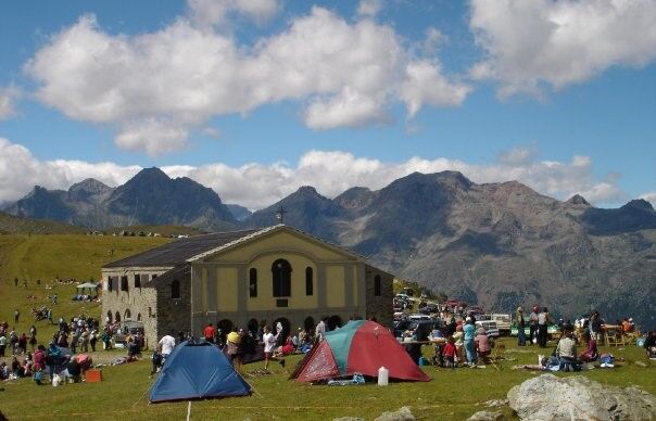
Yesterday as today important for the local pastoral economy on both sides of the valley, in 1705 the area saw the construction by a wealthy businessman from Lemie, a certain Giovanni Battista Giorgis, of a votive pillar which - from the first small chapel - over the decades grew to the complex architecture of today's Sanctuary of the Madonna degli Angeli, which has always been a destination for pilgrims and processions from the parishes of the neighbouring villages and the two valleys.
The site was a bone of contention between the communities of Mocchie and Lemie and in 1837 also the scene of a shooting during the religious festival in August.
The hike can start from the centre of Condove (1,500 m altitude difference) but also higher up, from the hamlet of Prato Botrile (2½ h ascent), or in the opposite direction from Lemie, whose original path is now a carriage road.From Condove, another consortium road from June to October also makes it possible to reach Colombardo by car/off-road motorbike.
Two festivals are held there every year: the second Sunday in July and the first Sunday in August.

Ja
Ja
From Turin: A32 Frejus motorway Turin-Bardonecchia, exit Avigliana Ovest - Almese.
GETTING TO LEMIE
From Turin: Provincial road 32 of Valle di Viù.
: Romanesque church of San Rocco, 18th-century church of San Pietro and Castle "del Conte Verde" (Castrum Capriarum). Chapel of San Bernardo (11th century) at Laietto, votive pillars along the route.
At Lemie: 18th-century Olmetti chapel, chapel of the Holy Shroud, chapel of San Giulio, parish church of San Michele Arcangelo, 15th-century stone bridge over the Stura, 16th-century painting cycle of the Confraternity of the Holy Name of Jesus.
Populære ture i området
-
5.0
Ovarda Lakes Ring
tungVandring 15.9 km -
Colle della Dieta - ring from Germagnano
Landevejscykel 41.7 km -
Alpine Ring from the Lys Pass
MediumVandring 15.3 km -
Laghi di Avigliana - Escursione facile, ideale per famiglie con bambini
lysVandring 9.25 km -
The ruins of the Baratonia castle, churches and puddles of Varisella
MediumVandring 10.1 km -
Turlo lakes loop from Malciaussia
MediumVandring 9.49 km -
Ring of religiosity - Lemie
MediumVandring 9.26 km -
5.0
Laghi Verdi e lago Paschiet
MediumVandring 7.51 km -
Lake Viana from Alpe Bianca
MediumVandring 5.56 km -
Goldtoni - Alpenbogen A118 Lago di Malciaussia-Balme
MediumLangdistance-vandresti 24 km
Vandring og sporing


Gå ikke glip af tilbud og inspiration til din næste ferie
Din e-mailadresse er blevet tilføjet til mailinglisten.