


Sværhedsgrad: T2


The stage takes place on the right bank, mostly on ancient mule tracks between wooded valleys, ridges, and open pastures, among the many alpine hamlets of the municipalities of Macra, in what was formerly...
The stage takes place on the right bank, mostly on ancient mule tracks between wooded valleys, ridges, and open pastures, among the many alpine hamlets of the municipalities of Macra, in what was formerly the Municipality of Albaretto, and Celle di Macra, the village of the anchoveers, rich in artistic testimonies of devotion.

Starting from the Arneodi hamlet (1,050 m), you cross the square of the main village in the Paschero hamlet and, after passing the last houses, following the mule track (signposts S25/GTA/PO) you descend onto the rocky ridge, which below also intersects the provincial road near a hairpin bend, then descends to the valley floor in the Bassura hamlet of Stroppo along the Val Maira provincial road (927 m).
Before starting the real route on the right bank of the valley, where the stage will unfold, it is possible to reach the Church of San Peyre (1,233 m) in about twenty minutes of climbing, built on a steep hill in a panoramic position following the mule track (signposts T30) or the provincial road.
From the Bassura hamlet, having crossed the main road, still following the S25 signposts, descending the steps of the small square, you pass under an arch and enter the small road that descends among the houses of the village until reaching a playground. Turning left, you cross a small bridge over the Maira and follow for a stretch the forest track through mixed woodland mainly of beech and larch, which turns eastward. Upon reaching the signpost with directional arrows, you leave the S25 route which turns right and continue on the track following the signposts S33/GTA/SI/PO (Occitan Routes): the itinerary corresponds to Stage 56 of the GTA and to E17 of the Sentiero Italia.
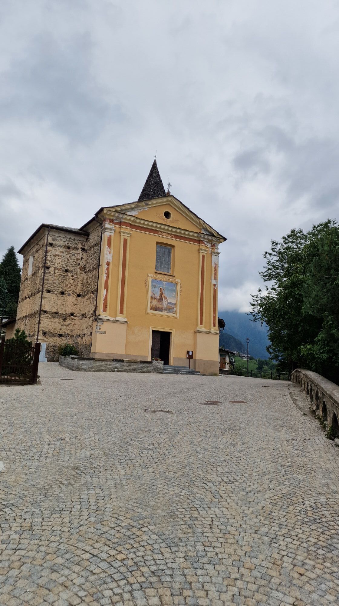
When the dirt road, after about 1 km, turns straight south to enter the hollow of Rio Mezzogiorno, you leave the track taking the trail that detaches on the left on a flat stretch and crosses the stream, following the profile of the small valley, then climbs with a series of hairpin bends in the dense forest of conifers and beeches towards the southeast along the slope. With a long almost flat traverse to the right, you cross numerous ridges and slight hollows, always walking in the thick of the tall wood vegetation; gaining a little height along the ridge of yet another small ridge, you brush a panoramic point, reachable with a very short detour, from which San Martino di Stroppo and the spur of Monte Beccone are clearly visible. Continuing along the traverse with a slight climb, you reach the chapel of the Madonna (1,301 m), built on a grassy rise. It is a beautiful and ancient building, with a large porch protecting the frescoed facade. From here you enjoy a panoramic glimpse of the valley floor.
You thus enter the Aramola basin which hosts part of the Albaretto hamlets. The mule track crosses, on the level, the hamlet of Aramola (1,301 m) with its large multi-storey houses, partly restored and partly in ruins, which testify to how inhabited it was in the past. The chapel is dedicated to San Bartolomeo, a characteristic square building with a porch and a square bell tower, which housed one of Albaretto’s schools on the upper floor.
From here it is worth making a climb variant of about 20 minutes to reach Borgata Palent (1,478 m) from where, following the beautiful carriageable track, you can directly reach Borgata Colletto, (1,414 m) where the path from Maurengo (signposts S33) also arrives, which continues gently climbing through the Aramola Hollow and with a nice traverse all inside a dense fir forest reaches directly among the houses of Colletto.
Avoiding the provincial road, you quickly descend with the mule track to Serremorello (1,316 m). From the church, with a wide grassy track, you descend quickly into the deciduous forest on the left slope of the Bedale valley, to Chiatignano (1,848 m) with some large houses, now almost abandoned, where once there was a “gabella” for collecting tolls. From here, on a path, you reach Borgata Sagna (1,098 m), already in Celle Macra territory, where once there were even vineyards toward Albaretto and tanks for hemp maceration are still appreciable. The short road from here leads to the asphalted road coming from Celle, which reaches Borgata Combe (1,063 m) with the remains of its ancient mills and a large “sail-shaped” building, where it turns, after the bridge over the stream, on a sharp curve on the opposite slope.
After a short stretch, on the right, marked by a directional arrow (signposts S21/GTA/PO/SI for Celle Macra) fixed on the wall, a little hidden by vegetation, you take the almost flat path above the road. The path passes above the scattered houses of Chiottetto (1,043 m) and reaches in the woods the Provincial Road 116 of Celle Macra near the bridge over the Bedale Tibert and the houses of the ancient Borgata Rio, a nucleus of medieval origin. Shortly after the hairpin bend, following the provincial road to the right, you encounter a climb near a retaining wall that continues on a small road that becomes grassy and arrives near a fountain and a votive pillar, where a signpost indicates the direction to Mattalia–Serre-Chiesa. In a few minutes you cross Mattalia (about 1,090 m). You cross the asphalted road and immediately to the left, well signposted by a signpost, you take again the mule track, flanked by dry stone walls, that climbs into the beech forest; you pass a stone cross and a tabernacle and continue uphill until you meet the asphalted road again which with a short stretch reaches Borgata Paschero (1,189 m). Here the stage ends and you can stay overnight.
T2
Borgata Palent: the hamlet is characterized by large houses leaning against the grassy slope, with typical columns supporting the facades, located in a splendid panoramic position. It also offers a stopover and an inn, and has recently become known for the cultivation of genepi and medicinal herbs. The hamlet has a chapel dedicated to San Magno, dating back to the seventeenth century. In the well-restored hamlet, some old wells for collecting rainwater are still present, the only water resource, very precious for watering the animals. The short additional climb is worth it to appreciate the vast panorama over the mid valley.
Celle di Macra
Cèlas in Occitan and Sele dl'Arma in Piedmontese, it consists of as many as 18 main hamlets, located on the well-exposed slopes of its valleys, as well as some scattered groups of houses. Like all the villages of the Valle Maira, it underwent depopulation especially after the war. Today it has just over sixty permanent residents, but still in the early '50s it reached about a thousand inhabitants.
The Borgata Chiesa hosts the Parish Church of San Giovanni Battista from the 14th century, later remodeled in Baroque style. The bell tower instead maintains its original structure with biforas and a pyramidal spire from the 14th century. Between the 17th and 18th centuries, it was almost completely rebuilt in Baroque style. But the real jewel of this church is the precious polyptych by Hans Clemer, the Master of Elva.
Spazio Pinse at the Museo Seles, near the parish church, highlights the popular devotion in the Alpine Valleys, the medieval autonomy, and the role of patrons such as the Marquisate. Great painters like Clemer or local artists like Boneto, as well as craftsmen from, for example, Provence, have left an iconographic and material heritage of sacred art works, in churches, chapels, votive shrines, and private buildings. The Museo Seles - of itinerant crafts is set up in the ancient Chapel of San Rocco and tells the story of crafts spread throughout the Alpine arc and others typical of the Val Maira, particularly that of the anchoveers, initially practiced seasonally.
In borgata Castellaro, Lou Chastlar, the highest in the village, stands the Castle or Cantunal, among the most monumental buildings of the entire valley.
The votive chapel of San Sebastiano, located on the road between the hamlets of Paschero and Serre, was built on the occasion of a plague epidemic in the 15th century.
The other main hamlets Bassura, Grangia, Ansoleglio, Soglio, Chiotto, Serre, Albornetto, Ugo represent architectural and landscape value with several houses of medieval origin, chapels, and works that deserve a visit through the Route of the Hamlets and thematic trails.
Populære ture i området
-
Gardetta Bike Emotions
MediumMountainbike 13.5 km -
Acceglio, bric boscasso
MediumSkitour 12.1 km -
Anello Intersile lago tempesta punta piovosa
MediumVandring 17.9 km -
5.0
Goldtoni - Alpenbogen A109 Sambuco-Ruata Valle (Stroppo)
MediumLangdistance-vandresti 36.8 km -
5.0
Goldtoni - Alpenbogen A110 Ruata Valle (Stroppo)-Refugio Grongrius Martre
MediumLangdistance-vandresti 28.4 km -
San Giacomo-Colle Valcavera
MediumLandevejscykel 13.2 km -
Codirossa - Kirche S. Peyre - Cucchiales - Codirossa
lysVandring 4.73 km -
5.0
Rocca le Meja - Valle Maira
tungHøj tur 19.8 km -
5.0
Occitan routes: Stage 6 Elva - San Michele di Prazzo
MediumVandring 11.5 km -
5.0
Percorsi Occitani: Tappa 4 Frazione Camoglieres - San Martino Inferiore
MediumVandring 16.8 km
Vandring og sporing


Gå ikke glip af tilbud og inspiration til din næste ferie
Din e-mailadresse er blevet tilføjet til mailinglisten.