The numbering of the historiated boulders depends on the sequence in which they have been marked and discovered over the years; the path was made later to facilitate their visit along an accessible, safe...
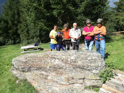
The numbering of the historiated boulders depends on the sequence in which they have been marked and discovered over the years; the path was made later to facilitate their visit along an accessible, safe route that respects the private property that the visitor may have to cross. Upon reaching Palueta bend, where one can conveniently park the car, a visit to the boulder 7 de li Caribona, which is located in a small clearing inside the hairpin bend, is suggested. This boulder has only three cup marks, but it allows one to understand how to locate the stones scattered along the trail: often they are found in large grassy clearings, other times somewhat hidden among the vegetation of alders, firs and shrubs. Having taken the forest road leading to Boeir, past the Rio Vallecetta in the locality of Campecc are boulders 8, 5 and 4 in sequence. Boulder 8, located some 20 meters beyond the stream just below the cartroad leading to the Incant, has 23 cup marks and as many as 32 crosses. Closer to the road, climbing the slope on the left, boulder 5 has six cupmarks. Boulder 4 is placed in the highest part of the pasture, clearly visible by the outcrop of polished rock on which there are 10 cupmarks some of which are connected by the characteristic drainage channels. Abandoning the road to Boeir, the trail continues by crossing the Rio Vallecetta on a small wooden bridge in the direction of Lecina. Having climbed the bank, after a hundred meters or so of slight descent, you regain altitude and cross a stretch of forest, mostly consisting of larch trees, to reach the Baita di Cagnola. Continuing on, in a wide clearing called Carbonin, boulders 1 2 are encountered. Boulder 1, of particular interest, has as many as 23 cupmarks of different sizes, one of which is very large (about 26 cm in diameter). Because of its location and shape, this boulder is also identified with the name altar boulder suggesting a possible function of these particular and very widespread archaeological sites. Boulder 2, just below and slightly discordant turns out to be sparsely surfaced by vegetation and preserves 18 cupmarks. To reach the other boulders one travels along a stretch of asphalt road in the direction of Bormio 2000 and near the hairpin bend one returns to the forest path, slightly downhill, until reaching the ski slopes. At Plan de li Fontana, on the high edge of the escarpment, boulder 3 with 23 cup marks is clearly visible, 6 of them arranged to form an arch. This non-random arrangement of the engravings (like the presence of drainage channels) has also given rise to various interpretations. Having crossed the Pista Stelvio, one travels along the junction that skirts the forest, and upon reaching the hairpin bend de li Stradela one can observe boulder 6 with its 8 cup marks. From here, having reached the Ciuk, go back on the paved road for about 500 m and past the stream take the small road on the left that leads to the Baite del Praculet (private property). Near the small wall on the left placed at the base of the barn door, it is possible to observe boulder 9 on which very close and well-preserved cup marks can be seen. At the conclusion of the walk we return to the asphalt road of Bormio 2000 about 1 km away from the Palueta hairpin bend.

Paluetta - Trosc - Campecc - Lecina - Garalt - Cagnola - Carbonin - Carcentina - Li Stradela - Ciuk - Praculet
Ja
Paluetta
Coppelle are spherical-shaped carvings of different diameters and depths made on monoliths of micascistic-filladic rock (rock with soft, workable grayish-brown hues common in these areas), using harder stones such as quartz, marble, or granite. There were mainly two carving techniques: by turning by rotating the point of the harder stone for a long time and by tapping by constantly beating the harder stone in a precise spot. Vast is the bibliography dealing with this type of rock engraving characteristic especially of the Alpine and pre-Alpine arc. The most reliable hypotheses would date these signs of the past from the Neolithic Copper Age (4th-3rd millennium B.C.) to very recent times. Historically, it seems that man made his appearance in our valley following the gradual retreat of the glacier that in very small part still dominates the mountain peaks surrounding Valdisotto. Initially nomadic hunters, men went little by little to populate our valleys (prehistoric settlement at Dosso Giroldo di Grosio a few km from here), devoting themselves to pastoralism and agriculture. Presence evidenced precisely by the rock carvings that also characterize Mount Vallecetta. The Coppelle still have great fascination today and stimulate our curiosity in search of an as yet unwritten truth. Historians and scholars claim that these stone cups served during sacrificial and propitiatory rites in pre-Christian tribes that used the boulders as erratic altars due to their natural conformation and position. The presence of the drainage channels connecting two or more cup-marks would suggest the blood of sacrificial victims (animals) or at best the water from nearby and numerous natural springs. Others argue that in more recent times (until the Middle Ages) the cupels arranged according to precise geometric criteria, served almost as a topographical map of the place or a sign of territorial delimitation, boundary, etc. According to more far-fetched hypotheses, the cupels (especially if small and numerous) would represent constellations. As for crosses, speaking of a historical period from the Middle Ages to 900, it seems they were engraved by the local people ando shepherds to ward off possible avalanches or natural disasters (see boulder 8). Local elders recount how, in the last century, the cup marks were used as a pattern of play and pastime during long grazing days. Warranting the prehistoric authenticity of the cupmarks is the obvious difference between those recently engraved with metal points and those of ancient and prehistoric workmanship, made only by stone-on-stone erosion.
Webkameraer på turen
Populære ture i området
Gå ikke glip af tilbud og inspiration til din næste ferie
Din e-mailadresse er blevet tilføjet til mailinglisten.


