The Cantinière forest
lys
Naviger
Naviger
Få denne tur på din mobiltelefon
The Cantinière forest
lys
Temaspor
2.96
km
Scan QR-koden, og start navigationen i bergfex -appen

Vandring og sporing


Afstand
2.96
km
Varighed
02:30
h
Opstigning
89
hm
Havets niveau
608 -
726
m
Download af spor
The Cantinière forest
lys
Temaspor
2.96
km


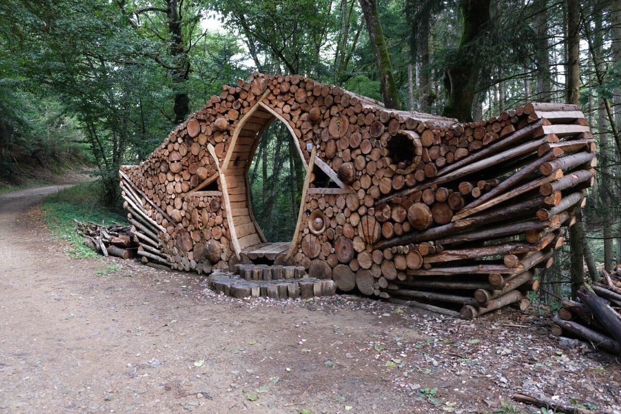
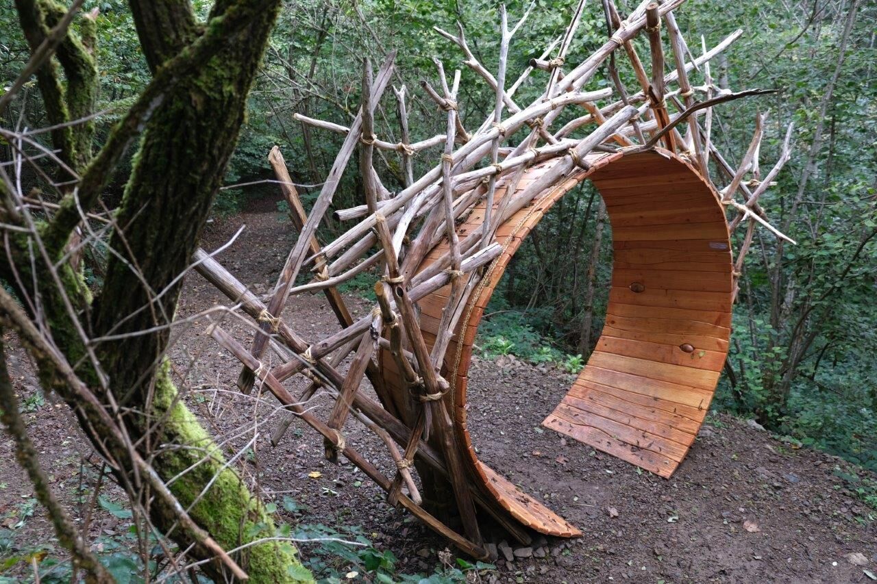
It extends over a massif located south of Beaujolais and is also classified as a sensitive natural area.
Many hiking trails criss-cross it: the GR®P du Tour des Pierres Dorées, the GR®76 and short hiking...
Beskrivelse af
It extends over a massif located south of Beaujolais and is also classified as a sensitive natural area.
Many hiking trails criss-cross it: the GR®P du Tour des Pierres Dorées, the GR®76 and short hiking trails taken from map guides. Fun workshops made of wood. The visitor is invited to soak up the atmosphere of the forest while contemplating the natural heritage it conceals.
Rute
Source de Fontfroide
(633 m)
Kilde
1.0 km
Rute
The Cantinière forest
lys
Temaspor
2.96
km
Source de Fontfroide
(633 m)
Kilde
1.0 km


Yderligere information og tips
Yderligere information
Espace naturel respecté par tous.
Ingen anmeldelser endnu
Populære ture i området
-
La forêt de la Cantinière - Beaujolais - Saint-Cyr-le-Châtoux
lysVandring 11.3 km -
De l’Aze à l’Ergues - Beaujolais Vert - Claveisolles
lysVandring 13.0 km -
The forest of Flachère - Beaujolais - Légny
lysVandring 6.68 km -
Hiking on the Voie du Tacot
tungVandring 77.0 km -
From Oingt to Col du Châtoux - Beaujolais - Oingt - Val d'Oingt
tungVandring 15.1 km -
The forest of Brou - Beaujolais - Dième
lysNordic Walking 10.5 km -
The golden stones - Between Pierres Dorées and Val d’Azergues - Loop 7.4
tungLandevejscykel 57.6 km -
Ma première nuit étoilée - Beaujolais - Tarare
tungVandring 36.5 km -
Les pierres dorées - Le tour des Pierres Dorées - Boucle 7.3
tungLandevejscykel 45.6 km -
Mont Brouilly, between vines and culture - Beaujolais - Saint-Lager
lysVandring 7.47 km
Vandring og sporing

Over 550.000 turforslag, detaljerede kort og en intuitiv ruteplanlægger gør appen til et must-have for alle naturentusiaster.

Gå ikke glip af tilbud og inspiration til din næste ferie
Tilmeld dig nyhedsbrevet
Fejl
Der er opstået en fejl. Prøv venligst igen.
Tak for din tilmelding
Din e-mailadresse er blevet tilføjet til mailinglisten.
Rundrejser i hele Europa
Østrig
Schweiz
Tyskland
Italien
Slovenien
Frankrig
Holland
Belgien
Polen
Liechtenstein
Tjekkiet
Slovakiet
Spanien
Kroatien
Bosnien-Hercegovina
Luxembourg
Andorra
Portugal
Iceland
United Kingdom
Ireland
Greece
Albania
North Macedonia
Malta
Norway
Montenegro
Moldova
Kosovo
Hungary
San Marino
Romania
Estonia
Latvia
Belarus
Cyprus
Lithuania
Serbia
Bulgaria
Monaco
Denmark
Sweden
Finland