© Schenna - Tourismusverein Schenna / Florian Andergassen
Turnédatoer
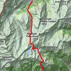
6,75km
572
- 1.449m
-
829hm
02:30h

- Sværhedsgrad
-
let
- Evaluering
-
- Rute
-
Schnugger1,3 kmSchenna6,7 kmMeran6,7 km
- Bedste sæson
-
janfebmaraprmajjunjulaugsepoktnovdec
- Højeste punkt
- 1.449 m
- Højdeprofil
-
 © outdooractive.com

- Forfatter
-
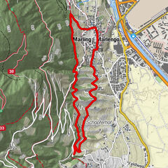
SchennaRundvisningen Hike from the Taser Alm to Scena bruges af outdooractive.com forudsat.
GPS Downloads


Flere ture i regionerne
-
Meraner Land
1736
-
Passeiertal
798
-
Schenna
306