© Appenzellerland Tourismus AR - Corinne Kunz

© Appenzellerland Tourismus AR - Daniel Ammann

© Appenzellerland Tourismus AR - Corinne Kunz
- Kort beskrivelse
-
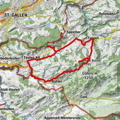
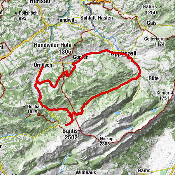
A fantastic circuit from Urnäsch to Appenzell and back again.
- Sværhedsgrad
-
tung
- Evaluering
-
- Rute
-
Urnäschref. Kirche0,1 kmRestaurant Sonne1,4 kmGrünau1,5 kmBergwirtschaft Blattendürren4,4 kmRose10,4 kmGasthaus Krone11,2 kmKatholische Kirche St. Verena11,2 kmGasthaus Bären11,3 kmCafe Rössli11,4 kmGonten (902 m)11,4 kmGontenbad13,8 kmKesselismühle14,9 kmRestaurant Rose15,0 kmAppenzell (778 m)16,4 kmPfarrkirche St. Mauritius16,9 kmKappelle St Anna18,4 kmRestaurant/Bäckerei Schäfli18,7 kmSteinegg19,1 kmKapelle St. Magdalena19,2 kmWeissbad (820 m)20,3 kmPizzeria Alpenhof20,7 kmWeissbad20,7 kmHagtobel22,1 kmUntere Bickeren22,4 kmAlthus23,0 kmRestaurant Warth23,4 kmEugst23,9 kmRestaurent Lehmen24,6 kmLehmen24,7 kmLeuenfall25,3 kmSiebenhütten32,5 kmSchwägalp33,4 kmTanne35,9 kmRiglen36,7 kmRossfall39,9 kmGrünau43,1 kmRestaurant Sonne43,4 kmUrnäsch44,7 kmref. Kirche44,8 km
- Bedste sæson
-
janfebmaraprmajjunjulaugsepoktnovdec
- Højeste punkt
- 1.394 m
- Destination
-
Urnäsch
- Højdeprofil
-
 © outdooractive.com


- Forfatter
-
Rundvisningen Potersalp-Route bruges af outdooractive.com forudsat.
GPS Downloads


Generel information
Forfriskningsstop
Kulturel/Historisk
Lovende
Flere ture i regionerne
-
Appenzellerland
151
-
Ebenalp
86
-
Jakobsbad - Kronberg
11