© Waldviertel Tourismus - Destination Waldviertel


- Sværhedsgrad
-
let
- Evaluering
-
- Rute
-
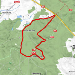
VitisPfarrkirche hl. Bartholomäus0,0 kmGasthaus Pichler0,2 kmTeichfeld2,6 kmGASTHAUS Weber Alfred3,3 kmJetzles3,5 kmStoies4,4 kmOrtskapelle4,5 kmGrafenschlag6,3 kmAlte Wege7,0 kmSchacherdorf8,1 kmEhem. Mautkapelle9,5 kmVitis9,8 km
- Bedste sæson
-
janfebmaraprmajjunjulaugsepoktnovdec
- Højeste punkt
- 583 m
- Destination
-
Vitis
- Højdeprofil
-


- Forfatter
-
Rundvisningen Teichweg bruges af outdooractive.com forudsat.
GPS Downloads


Flere ture i regionerne
-
Waldviertel
1776
-
Oberes Waldviertel
614
-
Vitis
129