- Kort beskrivelse
-
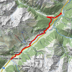
Walk up the sunny slope between Madulain and Zuoz to the cosy Alp Es-cha Dadour.
- Sværhedsgrad
-
medium
- Evaluering
-
- Rute
-
Madulain (1.697 m)0,0 km
- Bedste sæson
-
augsepoktnovdecjanfebmaraprmajjunjul
- Højeste punkt
- 2.055 m
- Destination
-
Madulain, station
- Højdeprofil
-
 © outdooractive.com
- Forfatter
-
Rundvisningen Alp Es-cha Dadour bruges af outdooractive.com forudsat.
GPS Downloads


Generel information
Forfriskningsstop
Lovende
Flere ture i regionerne
-
Engadin St. Moritz
102
-
Madulain
36