Turnédatoer
6,77km
677
- 741m
77hm
84hm
01:15h

- Rute
-
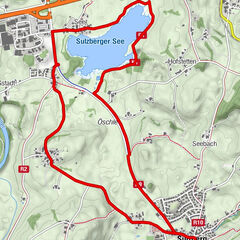
Ludwigshöhe1,0 kmBachtelweiher Garten2,4 kmMoos4,2 kmHinterholz5,2 kmMatthäuskirche6,3 kmKempten (Algovia) (674 m)6,6 km
- Bedste sæson
-
janfebmaraprmajjunjulaugsepoktnovdec
- Højeste punkt
- 741 m
- Destination
-
Parkplatz Lohmühltobel (Engelhaldepark)
- Højdeprofil
-
 © outdooractive.com
- Forfatter
-
Rundvisningen Kempten Nordic Walking Tour: Bachtelweiher bruges af outdooractive.com forudsat.
GPS Downloads


Generel information
Forfriskningsstop
Flere ture i regionerne
-
Allgäu
101
-
Oberallgäu
63
-
Kempten
10